
Taiwan is frequently visited by Typhoons. Most of them are moving passed the island but sometimes they also hit the island. When I lived in Taiwan I only once had a Typhoon struck northern Taiwan. Back then I lived in Taipei city, and apart of some rain and stronger wind, in the city center it (luckily) was not much more than a large storm.
Nevertheless it gave me an idea of the force of a typhoon. The constant rain and wind battling with the surroundings. I cannot imagine how it must have been in the 17th century, on settlements made of wood or on a sailing ship sailing in South East Asia.
I wondered if there are traces left of typhoons hitting Formosa? The Dagregisters of Zeelandia give an interesting insight in the day-to-day life of the Dutch in 17th century Taiwan. Although the writings sometimes are very brief, some important events are often more elaborate described. And yes, I found a story of a Typhoon hitting Fort Zeelandia in October of the year 1656.
Today I would like to share you this story: An event of the destruction most likely caused by a typhoon, to the Dutch Fort Zeelandia and it surroundings in the year 1651. I say most likely a typhoon because the Dutch back then did not used the word ‘taifu’, ‘typhoon’ or ‘Hurricane’ (Dutch: Tyfoon resp. Orkaan). Instead they used the words: ‘storm’, ‘vliegende storm’, or ‘grooten storm’ which translates to storm, flying storm and heavy storm, often combined with some descriptive elements how bad the weather was.
I will call this a typhoon, largely based on the damages it inflicted but also due to time of year and the description of the weather directions (rotating). Which combined, to me, give almost 99% certainty it was a typhoon which hit the fort and its surroundings.
[1] image credit, satellite photo typhoon
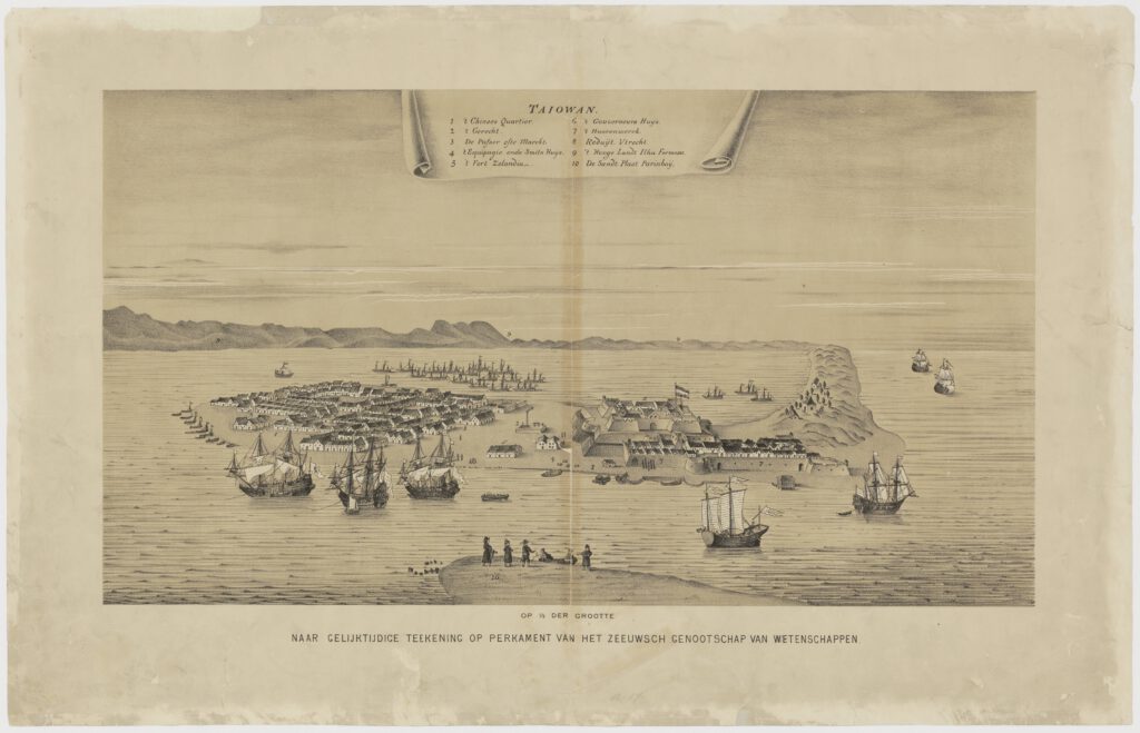
[2] image, view of Fort Zeelandia and the city of Zeelandia
Dagregister: Saturday October 7th, 1656
The water in the channel and the sea is rough. It is damp and humid weather. During the day we had a lot of rain showers with a strong south-easterly wind. During the evening a cold air came which resulted in a large storm from the same south east direction bringing heavy rain showers.
The yacht ‘de Zeehondt’ at the wharf (dock/quay) was taken care of extra, tied to land with several ropes, anchors and such. The same was done with the galliot ‘de Appelboom’ here to the shore.
The Galliot ‘de Roode Vos’, loaded with 400 chests of sugar to be shipped to Pehou at the first good weather, which was anchored outside the harbor*, where even some other smaller boats were overturned and swept away. May god save the Galliot for the same fate.
Some of the Champans here in the water have already sunk. The reported storm not only kept continuing during the evening, but also grew heavier more and more , as the wind turned to the south and southwest during the night and it became a terrible tempest we haven’t seen here in years. So much that all buildings shook and trembled, damaging them, many houses in the city Zeelandia collapsed reducing them to rubble piles.
The great force of the water flooded most houses, the water level rose so high that people could sail with chiampans on the lower parts of the city. Many people who fled from their houses were saved by these chiampans.
About 03:30 AM in the early morning, as the wind turned west, the thunder storm calmed down a bit. The flooding in the north and eastside of the city was still over half the height of a man, reaching all the way to the walls of the hoornwerck*** of the northern bastion of the fort. However soon after the water level slowly dropped.
* leyt op stroom: op stroom (van schepen), op de rede of op de open rivier, buiten de haven : op stroom liggen
** Chiampans: southeast Asian ship type
*** de muyren deses hoornwercks, outer walls of the bastion; location number. 7 on the city drawing above
Dagregister: Sunday October 8th, 1656
Early morning at sunrise we saw the Galliot ‘De Roode Vos’ for the first time again, drifted away from where it was anchored the day before. It was moved over the eastside of Paxemboys sandbar towards the Sinckan river where it was grounded in the clay soil.
Also, what amazed many people, we saw that the wreckage of the Yacht ‘Maerssen’, which was toppled and still grounded to the bottom with 2 anchors before, was moved a musketshot distance towards the village of Saccam, and stood almost upright! This could not have been done without an immense force. Some sailors where sent to there to get all the guns from the constable room*
*constabels camer: constabelkamer, constapelkamer, room in the stern of the ship at the level of the lowermirror (onderspiegel) , which serves as workspace for the ships gunners.
The dock in front of the Fort is washed away so much that not a single wooden post could be found. We shall need to replace it with new ones, yes even the stone structure below the fort and along the embankment have been washed away, many boulders were washed further ashore and the road beneath the fort and the Hoornwerck was damaged so much that many repairs are needed.
The yacht ‘den Zeehont’, as said before, secured tightly with anchors and ropes to the shore, had some of the ripped from the ground and dragged into the water and while most of the anchors were still connected to the yacht, the yacht still lost both of her masts as if the sea in the channel has been so rough and strong, it looked like the ship went sailing in the open ocean. So fiercely it had been tossed and flung around, it was forced after the large mast broke, to also let go of the foremast in order to keep the yacht afloat.
The Galliot ‘den Appelboom, still secured to the shore, for which we praise the lord, as well as the safety of Galliot ‘de Roode Vos’. A small raft of ship ‘de Vreede’ docked in the Zuyderhaven (southern port) was floated ashore by the high water level all the way to the house of Cabessa Pincqua. Actually all the shore of the Zuyderhaven as well as the Kerkstraat (churchstreet) were covered with Chiampans and coyas. Also much firewood and charcoal drifted stored next to Pincqua’s home was scattered around.
Even a large Coya was capsized upside down at the end of the Zuyderhaven . Next to the Zuyderhaven, in the lower part of the city, almost all rooftiles were blown to pieces, turning them in piles of stone. Yes, even the best ones, just recently placed, in particular most houses on the north- as well as t the east shoreline. Also many in the Zuyderhaven and probably also the houses on the other side of the port which also just had new rooftiles at the front.
Pincqua and other buildings in the kerkstraat (church street), yes, maybe one street less affected than the other but no street was free of collapsed houses. In the street we found also multiple bodies of dead Chinese women and children. Which doubled our saddness. In short, the city of Zeelandia was almost a desolate place, being so altered by the storm. We do have to note than many people have saved their lives in an astonishing way. While no house inside as well as outside the fort has been without any damages on their roof or walls.
But as we turned our eyes towards the sandbank of Paxemboy, where the Chinese fisheries once stood. We did not see any house left on the bank. every single one of them washed away and buried by the flood. We could see no sign of life on that side of the of the island, we must assume that all fishermen who docked their ships their or had their homes there must have been swept away by the flood and drowned together, wives and children included. As we did not hear anything from them anymore. This greatly saddened the citizens of Zeelandia who had friends there.
The most serious disaster for the Company (VOC), as far as we know now, caused by the storm. Is that with great sorrow heard that Reduit ‘Zeeburgh’, also located at the sandbar Paxemboy, last night at 00:00 when the storm was at its strongest, under influence of the force of the water and extreme wind, suddenly collapsed. The stone walls and wooden beams fell together, killing 5 Dutch and injuring most of the people who got away. Some of them had their arms or legs broken or other serious injuries. Among the injured also was the Sergeant of the army unit stationed there. We all looked at this with great sadness.
And as we turned or eyes from the North side, and look at the south side again with more sadness we saw that all the fisheries and 3 fishing villages located at the ‘Pijnappels’* were completely destroyed and taken by the flood of the water. So much that we fear that the number of people who were killed there might not be less but even more than those who got killed at Paxemboy. Because we could not find any house left standing on that side of the shoreline but as we know before there lived many people. We heard that in one of those fisheries the bookkeeper of the Galliot ‘den Appelboom’ and another soldier drowned as they went there for some entertainment.
On several places among the ‘Pijnappels’ the sea had broken the peninsula connecting to the inner water. It did so with such force that high dunes with pine trees were drifted away and destroyed. At one place the waterway was as much as 3 musket shots wide, in another place the distance was smaller but it was 6 feet deep! having multiple gaps and holes. As there were no signs of any people there, they must have not been able to flee and thus must’ve drowned.
On several places among the ‘Pijnappels’ the sea had broken the peninsula connecting to the inner water. It did so with such force that high dunes with pine trees were drifted away and destroyed. At one place the waterway was as much as 3 musket shots wide, in another place the distance was smaller but it was 6 feet deep! having multiple gaps and holes. As there were no signs of any people there, they must have not been able to flee and thus must’ve drowned.
Across ‘t nauw ** the water pushed so heavily against the mainland that some courtyards and rice fields were flooded, also along the Saccam shoreline many houses and fields were overthrown.
Also houses in part of the city, at which the Chinese lived, were blown over.
The carpenter’s shop behind the Fort, at the westside, was also collapsed. The houses of the carpenters washed away and on that side all the hills were flattened by the storm, so that all the land up to ‘de pijnappels’ was plain and flat, most of it still under water.
We desire to know how it is with the city of Provintia and the surrounding lands, as well ass our outposts at Wanckan, Caya, Lackjemoya, Jockan and others. During the last storm. when the Yacht ‘Maerssen’ was capsized, some villages and churches already blown away. But today we fear, as this storm was much heavier, we will soon get news of much more discomfort and damage.
The Governor and only member of the council, visited the City of Zeelandia in the morning. He firstly tried as good as possible to create some order. He announced anyone who tried to take, steal or carry goods from the damaged houses would be chained for a full year to be put to labor on community projects. To take care and protect the people left in the city, an officer and his law enforcers patrolled the city and some soldiers led by a corporal stood guard and kept watch over the city.
During the day the weather cleared, the wind came from the west and turned north in the evening.
*the name of the southern part of the peninsula at which Fort zeelandia was built. The name ‘pijnapels’ came from the pine trees (Dutch: pijnappelboom) which grew in that area.
** ” ‘t nauw” ; probably the name of area of the inner bay between Zeelandia and the city of Saccam. not sure yet.
Dagregister: Monday October 9th, 1656
Monday morning the 9th of October the weather was very good with sunshine.
Personal remarks
I tried my best to make a direct translation of the texts from 17th century Dutch, to regular Dutch to English. Nevertheless it could quite possible be that some nuances or details got lost in my translation. Down below I state my references, so for a more deep dive into the sources you can look into the references stated below.
References
The main source for this article are the dagregisters of casteel Zeelandia, Part 4, 1655-1662, p111-113
[1] NASA image courtesy Jeff Schmaltz, MODIS Land Rapid Response Team at NASA GSFC, Public domain, via Wikimedia Commons