estimated reading time: 17 min.
Table of Contents
Introduction
During the 4 decades the Dutch East India Company (in Dutch VOC) ruled over Formosa they build several forts and fortifications to protect their possessions from outside threats. Today I would like to dive a bit deeper into these defensive buildings, where were they built? What did they look like and what remains of these structures after 400 years? First we dive a bit deeper in the VOC expansion in south east Asia. Then we will discuss the types of defensive structures.
VOC expansion and trading strategy
Since the earliest Dutch ships arrived in the east indies the trading strategy of the Dutch was to take over trade with force. they were granted the semi governmental power that is to wage war, negotiate treaties, and convict people who did not obeyed their rules.
This also meant they could hamper enemy trade by attacking enemy (European) ships such as the Spanish and Portuguese. But also negotiate treaties with friendly tribes and kingdoms or waging war hostile ones.
At important locations trade outposts where build and often these were protected by Forts and soldiers. Sometimes they even took over whole islands in order to control the production of valuable spices, killing or enslaving all its inhabitants.
Forts, Reduits and Barricades
There are several different defensive structures the Dutch VOC have build in de East Indies to protect or take over trade. These we will discuss in short before we continue with the VOC forts on Taiwan.
Forts: These are the biggest of the 3. In the 16th century cannon warfare was on the rise and thus the forts were constructed of thick walls of earth and bricks. Most of them had moats around them too. On each corner bastions with cannons were placed. Smaller fortifications were square shaped but larger ones where star-shaped. Often the fort was placed on a peninsula and protected both the entrance of a harbor as well as the nearby town or city. Bigger cities also had city walls or fortifications placed around the city.
Reduit: A Reduit is a small fortification used to defend an important position. This could be build on a hill to protect an important waterway, prevent enemy from landing or defend a weak side of a fort or city. Sometimes a Reduit was used as a permanent forward fortification. A handful of soldiers inside a Reduit could often defend against a large number of attackers.
Barricade: A barricade is a defensive structure often used as a temporary base for troops to fall back to in military expeditions sometimes also in forward expeditions. These were often made of wood and earth walls and offer protection from light attacks and ranged weapons. Often soldiers armed with muskets or sometimes small cannons could be used to fend these attacks off.
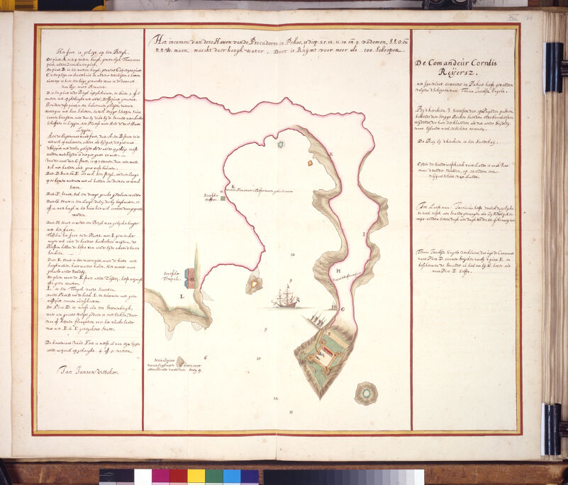
Dutch VOC forts at the Pescadores
In 1622, after the failed attack to capture the Portuguese city of Macau, commander Cornelis Reijersen of the Dutch fleet decided to relocate and build an outpost on Pehou (current day Penghu) at the Pescadores. From there they could control shipping and trade at the Fujian coast and force the Chinese into trading with them. Their plan was to force their way into the Chinese trade!
Of course the local Ming authorities did not like this idea very much. Knowing nothing about the war for independence between the Spanish, Portuguese and the Dutch back in Europe they just saw the Dutch as by their actions: as pirates. The Dutch not only attacked their long-term trade partners but also raided both ships and villages and thus hindered trade on the Fujian coast.
Soon after they gathered a fleet and they sailed to the Pescadores. During the year 1624 the Ming forces at the Pescadores grew and by mid august the Dutch were surrounded by 10,000 men and 200 ships. Stuck in their fortress, soon the Dutch governor had only one choice which was to start negotiations with the captain Li-Dan (also known by the Dutch as Captain China))
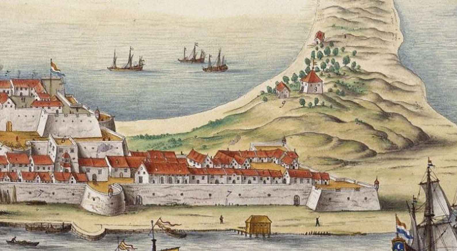
Fengguiwei Fort
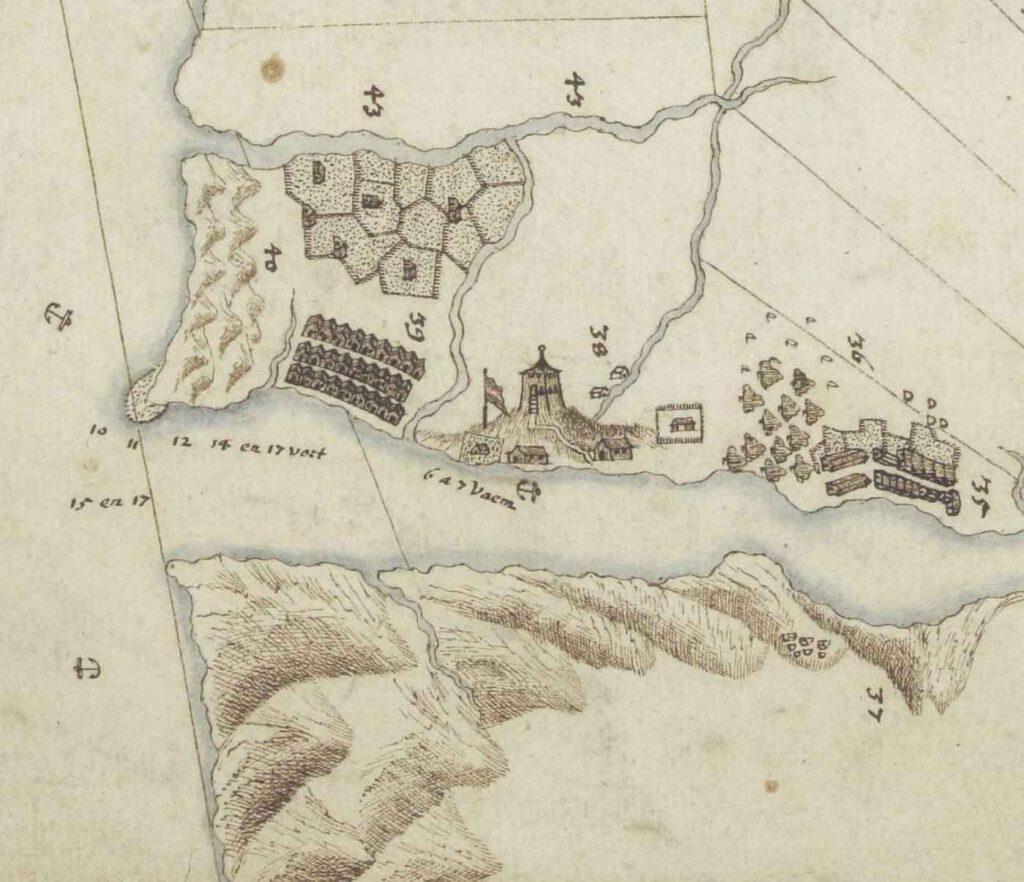
The fort was built at the tip of the peninsula on top of a small hill known as Shetou mountain (蛇頭山). The fort was looking over the bay opposite of Makung harbor. Three of it sides are were cliffs/rocks coming from the sea and at the other side a trench was dug.
The fort was build by slave labor. Both locals as well as men captured during raids on the Fujian coast were forced into building the fort. It is said that of the 1500 locals building the fort about 1300 died due to starvation and other hardships.

Description of the Dutch fort in Pehou
So what did the fort look like? well, luckily we have a very accurate description of the fort both in drawing and text.
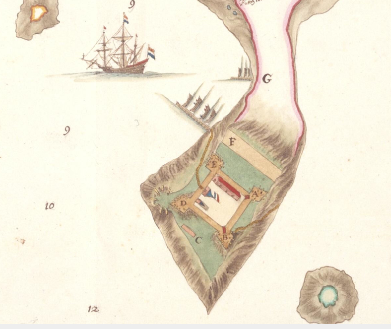
A: Bastion A is 24 feet high.
B: Bastion B is 22 feet tall and called: “Capiteijns punt” (captains corner).
C: is a square to store firewood and other items. with time a small house is constructed for the storage of rice.
D: Is a bastion carved from the cliffs. On top it was raised with 5 or 6 feet of earth. This bastion is called “delfs punt”
below this bastion a half moon was built. From there cannons can shoot horizontal towards enemy ships. And protect the small harbor with the pilot ships.
F: here a dry trench was dug.
G: at this location a low valley was located. at high tide this would be 10 to 12 feet above water level.
(picture below)
H: A hill at equal height as the fort was located.
I: Between the fort and this location about 100 cattle could graze.
K: Here a well was located. At low tide a boat could fetch fresh water from here.
L: Is a Chinese temple
The only way to get to the fort was to take the path. From the outside, you could not climb up the side with points A and B,
On the side C you can climb, but with great difficulty, because you need both hands and feet to hold on to the grass. Also at the side E and D you need both hands and feet to climb up that side of the hill.
The Inner Fort was raised by about 4 to 5 feet. No descriptions of the inner buildings are written down.
From Bastion D they can protect bastion E, the trench F, and the beach all the way up to G. This was even more than Bastion E could protect.
Present day Fengguiwei Fort
According to the French Jesuit Joseph-Anne-Marie de Moyriac de Mailla, in 1715, there were no remains of the fort; only its description, which the Chinese called the “castle of red hair.”
During the Japanese colonial times of Taiwan an artillery battery was placed to protect the entry of the bay but those were removed after the end of WWII.
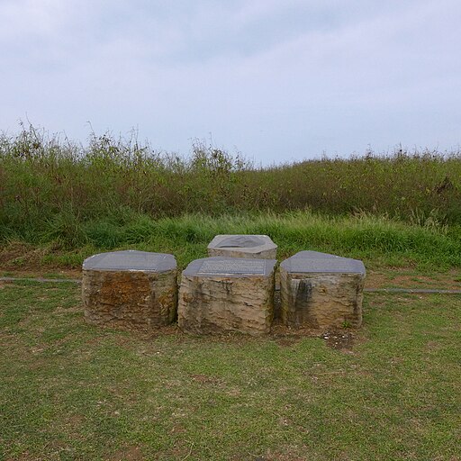
Present day not much is left of the fort. There are some informational plaquettes and signs at the location explaining the history of the place.
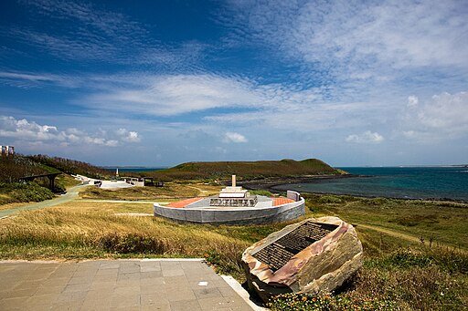
In the picture below the explanation sign of Dutch fort Fengguiwei can be seen. It is placed about where the central square of the fortress was.
Dutch VOC Forts in Southern Taiwan
In 1624, under pressure from the Ming forces the Dutch governor Martinus Sonck signed a treaty with the Ming captain, to deconstruct the fort at the Pescadores and move to a new location at Taiovan on the nearby island of Formosa. Part of the agreement was peaceful trade with the Dutch and no Chinese junks would sail for trade to the Spanish town of Manilla.
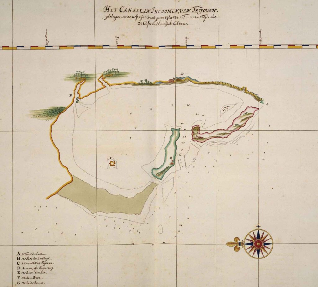
Fort Zeelandia (An ping)
Early years of Fort Zeelandia (1622-1623)
Already as early as 1622 a wooden palisade was build at the sand dunes on the peninsula at a place called Taiovan in order to trade with the local (chinese and Japanese pirates/smugglers). However when the fort at the Pescadores became under siege the Dutch demolished it to focus all their resources on the defenses at the fort at the Pescadores. However as soon as the treaty was signed it was decided to rebuild the fort and trade outpost at the peninsula at Taiovan.
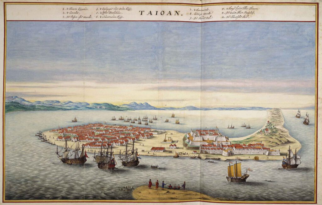
The image below shows the fort in about the year 1627. The wooden fort has been placed with a stone fort. A wooden palisade still surrounds the area. A path from the fort runs to the waterline where the warehouse was placed. If we look slightly to the left we see a gallows and the market house. Often, a gallows was set up in a public place so that everyone could see what happened to those caught stealing or killing.
The market house was the place where goods were traded. In the left corner of the image we see the city of Zeelandia, placed at the tip of the peninsula, safely protected by the fort.
Expansion of fort zeelandia (1635)
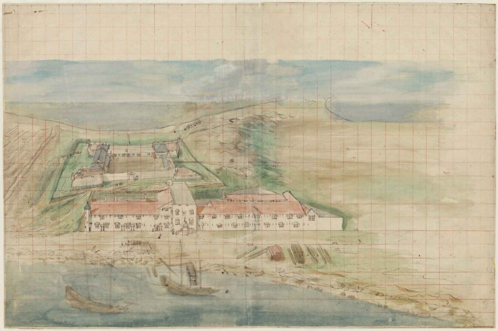
in the 1630’s it was decided to expand the fort by expanding the warehouse, building a governors house, the hospital, living quarters a church and several other buildings in front of the existing fort. The image below shows a sketch of the situation around 1635. In the middle you can see the governors accommodation with a flat rooftop. On top cannons could be placed if deemed necessary to defend the place. Building materials such as bricks and wooden beams still lay at the coast ready to be used.
External walls and bastions: Fort zeelandia in its final form. (1650)
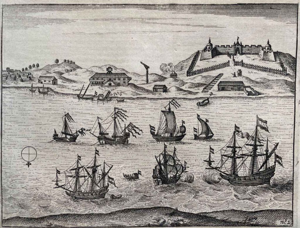
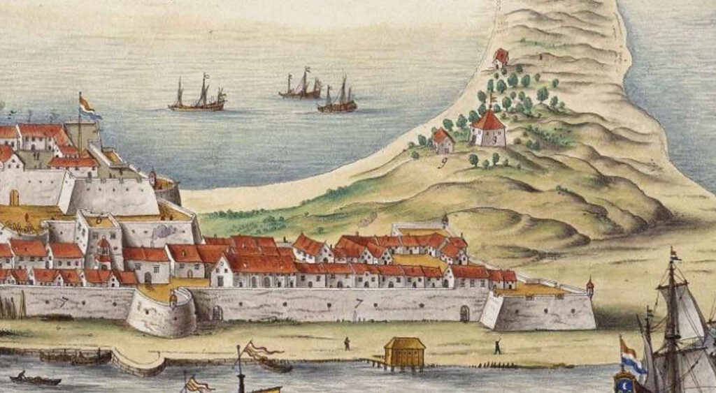
Eventually the council at Formosa decided the extension needed protection too. An external wall and more bastions were placed to protect the buildings. The trading outpost ended up in its final form. In the image below, we can see what the fort and city must have looked like in its heyday as seen from Baxemboy Sandplate.
We see several sailing ships sailing into the bay of Taioan. In fact only the smaller ships could sail safely into the bay. The larger ships often moored at a nearby location at open sea. Towering majestically over the city, we see the white fortress with its strong, thick walls. Protecting both the city as well as anyone who dares to attack from the sea. Left we see the city of zeelandia several streets and alleyways full of houses and small shops. many small boats and sampans of both fishermen and trade merchants are moored at the coast.
On the right hilltop next to the fort we even can see the small reduit Utrecht. An extra defense built to withstand an attack over the landside of the fort. Which we will discuss the importance of the reduits later.
After a nine month siege the Dutch surrendered the fort to Zheng Cheng-gong (Koxinga) in 1662. For a while the fort was used by Koxinga but in the decades that followed, the fort slowly fell into disrepair and when we arrive in the late 19th century the fort was a ruine. Often brick and other raw materials were re-used by the locals to to build or repair their own houses.
In 1874 the Qing officials used bricks from the fort to construct the fort eternal golden castle at the coast of Tainan. then, two decades later in 1895 when the Qing dynasty ceded Taiwan to Japan the Japanese further leveled a part of the fort by using the brick to build a three story brick platform with a mansion on top, also dormitories for customs officers and a lighthouse were built.
In 1908 location slowly became a heritage location as the residential housing around the platform where demolished and the mansion was turned into an exhibition room. The lighthouse stayed and was used in WWII as observation platform by the Japanese to monitor American bombers.
Present day fort zeelandia
Present day the old fort (of Zeelandia) An-ping is turned into a museum, you can visit the leftover remains of the walls of the fort. ground foundations of the bastions. Below, next to the old wall of the fort a small museum telling the history of the fort and the An-ping district is located. You can climb the fort stairs and find the mansion on top, now turned into a museum shop, (it has air-conditioning!) or climb in the old lighthouse and enjoy the view (not great: the windows are dirty!!).
Its good in recent years the history of the place is acknowledged and the story is told to the Taiwanese people! If you visit the place also wander around in the An-ping district. Although there is nothing left of the old Dutch houses, the streets and alleys still gives a feeling of the old days. The main street also has fun little shops and food stalls.
Fort Provintia (Chihkan Tower)
Fort Provintia
Fort provintia was built in 1653. It was located next to the coastline of the inner bay opposite – Fort zeelandia.
It was a small fortification which could be used for the soldiers to fallback in case it was needed. (the years before several Dutch were killed in a rebellion.)
Present day Chihkan tower
Present day the place is a historical heritage site and turned into a museum. Inside the Chihkan Tower a model of how Fort Provintia could have looked like is displayed. Both in 2023 and 2024 when I was in Tainan it was under construction and renovated (although the museum was still opened). I hope soon they will finish renovating so it can be seen fully again.
Of the old Dutch fort part of the entrance is still visible and in a part of the building the brick foundation has been uncovered. The photo’s above are of 2019 and 2023.
Dutch VOC Forts in Northern Taiwan
Ever since the Dutch knew the Spanish also had settled in the Northern part of Formosa they wanted to remove them from the island.
In 1642 an army was raised and the VOC attacked, and conquered, the Spanish fort Trinidad at Keelung (heping island) and renamed it Fort Noord Holland.
If you want to learn more about the Dutch conquest of Spanish Formosa, I’ve written about it in a separate blogpost which you can read here.
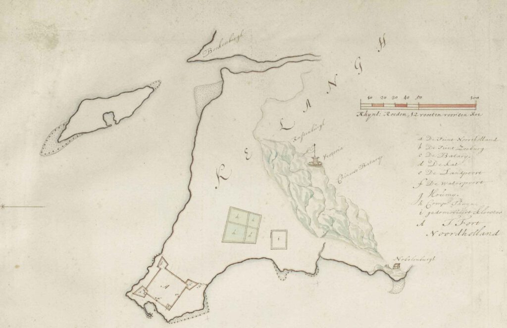
Fort Noord Holland (Trinidad)
Fort Noord Holland was used by the Dutch as an extra trade settlement between 1642 and 1662 when it was abandoned.
The fort had 3 pointy bastions, the fourth corner was squared and facing the inner bay. The land-side of the fort was protected by a moat to make an attack difficult.
After the conquest of northern Taiwan in 1642, the Spanish were gone and the island fully under VOC control but also the Dutch signed a peace treaty with Spain in 1648. It deemed not necessary to have such a large fort so in the years following the Dutch slowly took down the fort.
Its raw materials were used to build and strengthen a stone fort at Tamsui. In the end only the bastion Noord-Holland, protecting the entrance of the bay, remained.

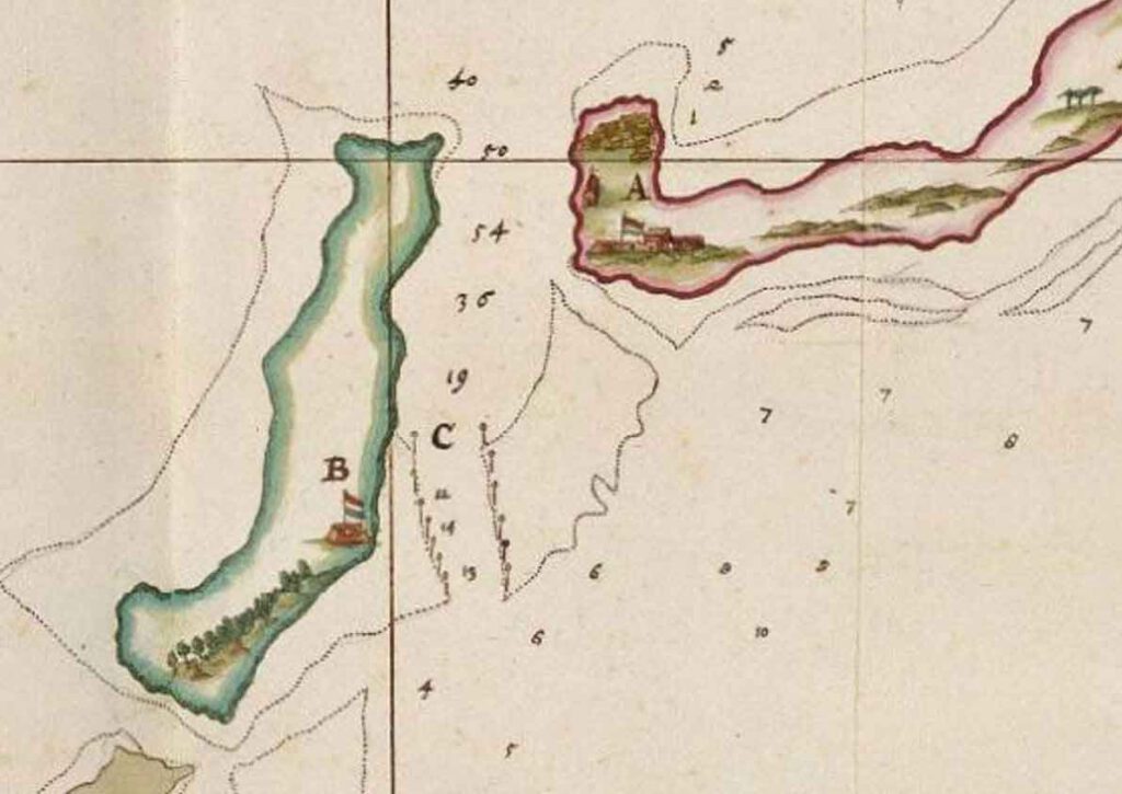
The names of the bastions (picture below) are:
A: the bastion Noord holland
B: the bastion Zeeburg
C: bastion De batary
D: the bastion de kat
The fort had 2 gates, one on the landside and one on the seaside accessible via boats:
e: the land gate
f: the water gate
The demolished Spanish monastery (i), the company gardens (h) as well as the Reduits Victoria and Nobelenburgh can bee seen on this map.
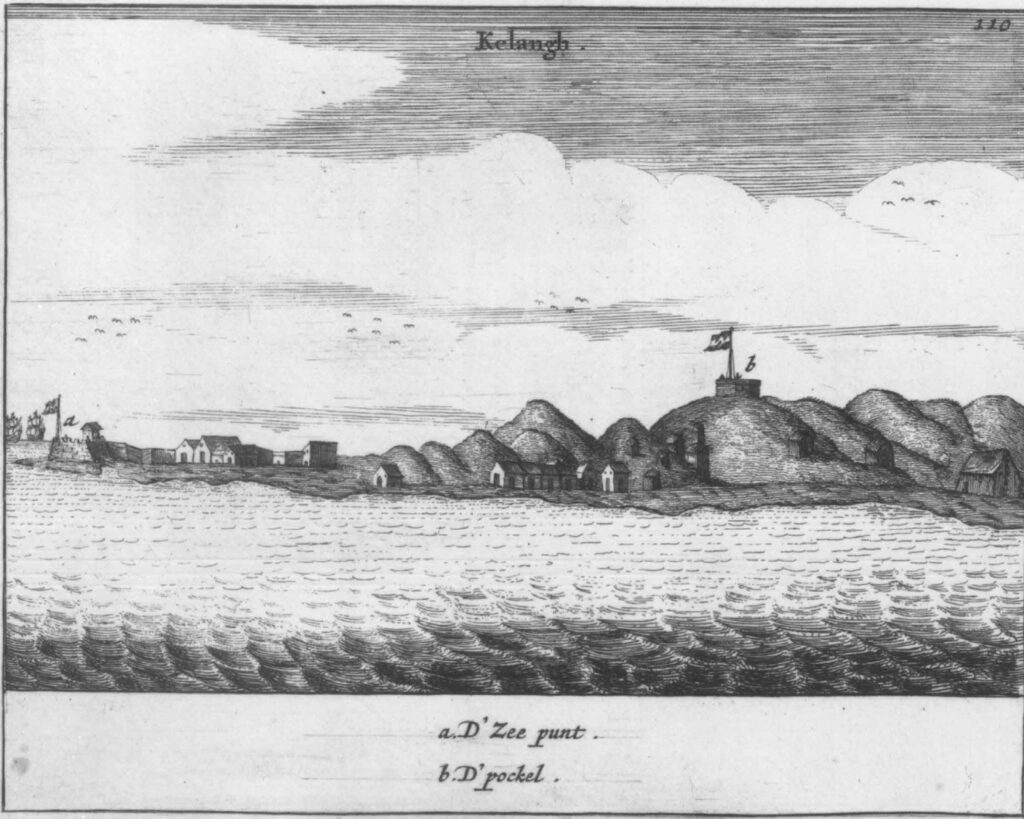
After the defeat by Koxinga in 1660 the Dutch tried to settle once more in Taiwan during the 1662-1665 expedition by Balthasar Bort. They settled for a few years at Keelung before deciding in 1668 to abandon Taiwan for good.
Below an image of the view at Keelung (heping island) in 1664.
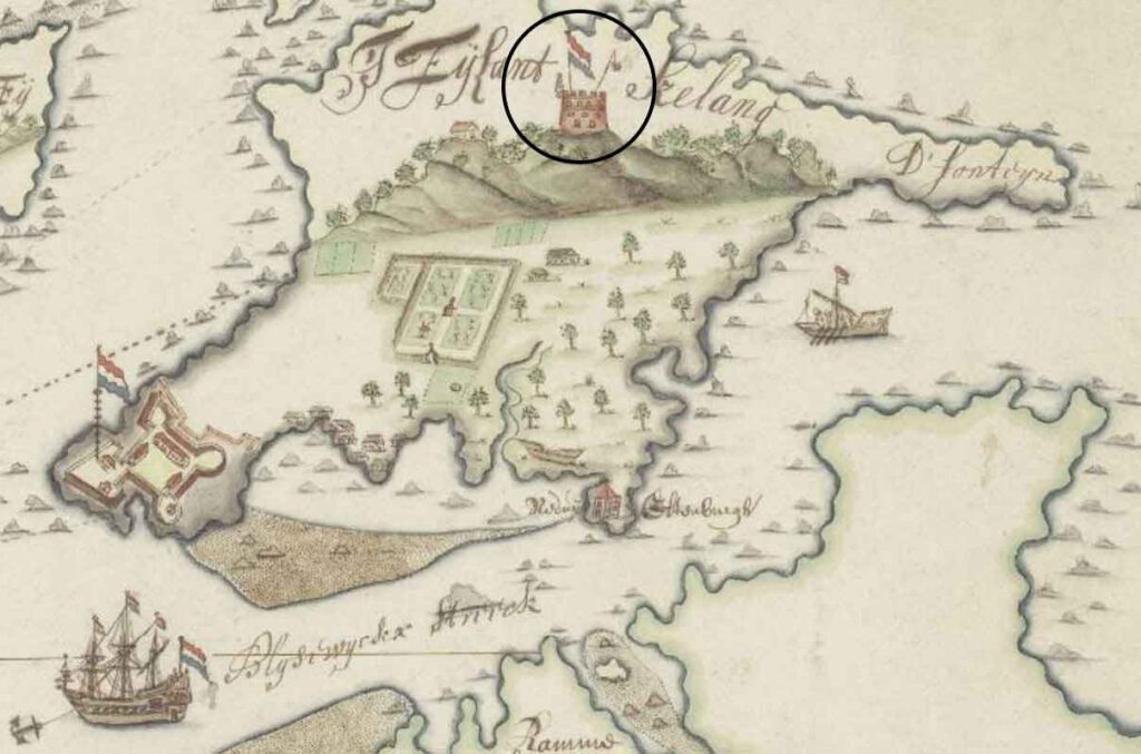
This fort was renamed and known as Fort Nassau
We can see the bastion Noord Holland, now less formally known as ‘de zeepunt’ (sea point) on the left with Dutch East India company houses next to it. In the middle of the image we see a small village and on top we see the reduit Victoria, now also known as ‘De Pockel’ which was used as observation point on top of the hill.
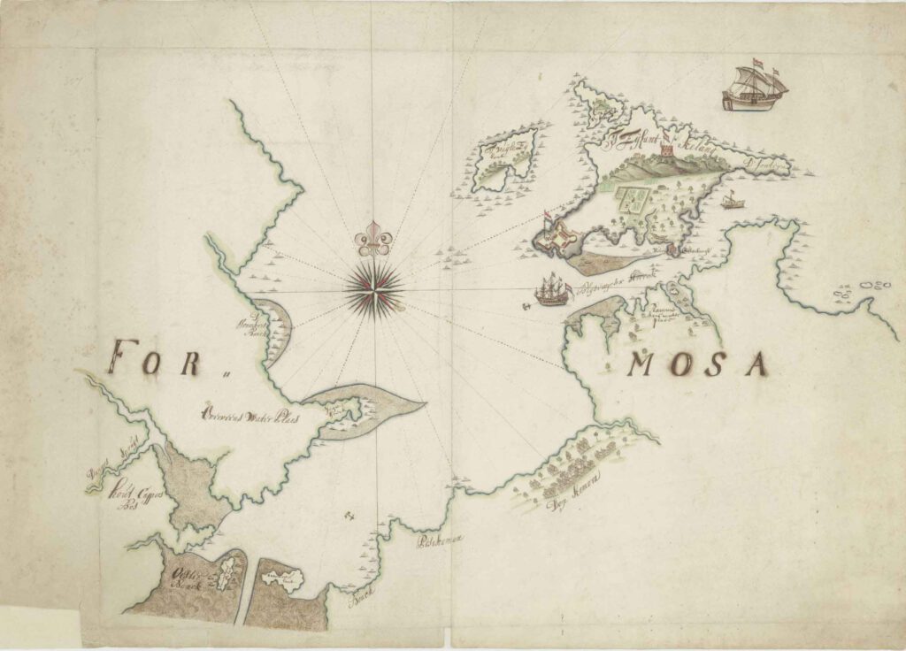
Fort Antonio (Santo Domingo)
Fort santo domingo is a historical fortress standing in Tamsui district, Taiwan.
When the Dutch defeated the Spanish they wanted keep a fort at its current site in Tamsui. From the fort they could control the important trade of sulfur and deer skin and other trade on the Tamsui river.
In 1644 they replaced the wooden structure by a stone structure. The fort itself was a square building with thick walls, placed on top of a hill. Which is still standing there to this day. Interestingly it is known by its Spanish name Santo Domingo. It has been turned into a museum and you can visit it.
Extra defensive structures: Reduits
As mentioned before Reduits where extra defensive structures. Sometimes defensive weaknesses where spotted which needed to be addressed. It was not always possible to make adjusted to the main fortification due to geographical constraints or poor initial choice of its location. Some of the important reduits I would like to mention here.
Reduit Zeeburg
already very early on the council at fort zeelandia were concerned about the possibility an enemy force would occupy the sandbank of baxemboy opposite the fort and the city of zeelandia. If that would happen they could construct a battery which could should at the city. Therefore it was decided to build a small reduit, as stone fortification with few cannons on the island of Baxemboy.
Reduit Utrecht
When Rumours spread that Koxinga might come to attack the fort the council realized the fort was optimal prepared for a siege. They realized that by building the external extension this had influenced the strength of the fort. The main fort did not had a free line of sight with its cannons to fence off an attack. They could place cannons on the, now also fully walled, extension but they faced another problem: the nearby dune hill was higher than the fort walls. This meant from there they could be attacked!
Therefore it was decided to build an extra defense on this hill. Reduit Utrecht was a stone fortification which protected this side the fort Zeelandia.
Reduit victoria
Reduit Victoria stood on top of the hill at Heping island. It was built by the Spanish to spot ships at sea but most importantly: to protect the fort below from being besieged. The Dutch realized this and after landing on the other side of the island they attacked the reduit. After heavy fighting they managed to take it from the Spanish. As soon as the Spanish governor saw the Dutch conquered the hilltop and they started to build a cannon battery he knew the fort would be lost and so he decided to surrender.
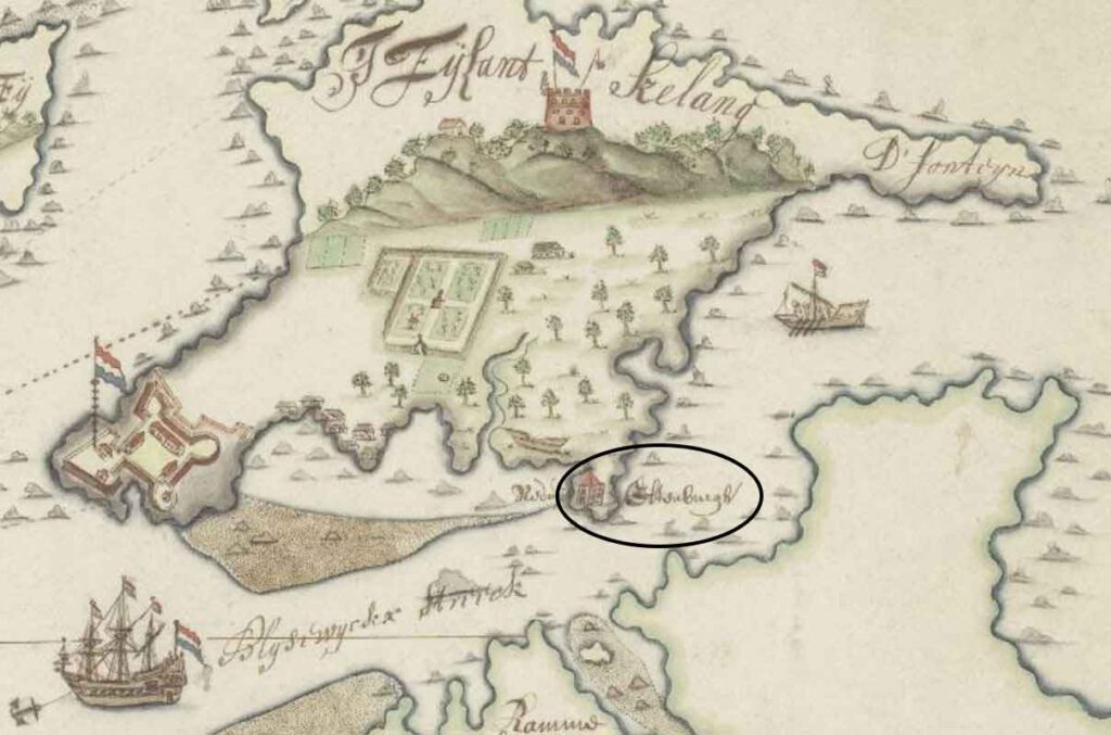
Reduit nobelenburg
The Dutch evaluated the defenses at Heping island and they saw that there was a small waterway opposite Heping island. To prevent an enemy from passing and/or landing they decided to build a small reduit called Nobelenburg at the end of the other side of the island.
Reduit Vlissingen
I know another reduit existed near the river of Wancan. This was an important location for raw materials for Fort Zeelandia. As the river was also used by smugglers to trade with the locals as well as nearby tribes were hostile it was decided to build a small fortification at the mouth of the river. However at some point due to storms and high water the structure was so damaged it was decided it had to be abandoned.